 geonetworktest
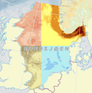
Uncertainty in accumulation rates of OC - North Sea/Skagerrak
Uncertainty in modelled accumulation rates of organic carbon (OCAR) in the top 10cm of seabed sediments of the North Sea and Skagerrak; g/m2/yr
Simple
Identification info
- Date (Creation)
- 2021-10-22
- Date (Publication)
- 2021-10-22
- Date (Revision)
- 2024-06-07
- Purpose
-
The purpose of the service is to visualize spatial variation in modeled geological parameters in seabed sediments. The uncertainty shows how uncertain the model estimates are.
- Status
- Completed
- Maintenance and update frequency
- As needed
- GEMET - INSPIRE themes, version 1.0
-
-
Havområder
-
- Nasjonal inndeling i geografiske initiativ og SDI-er
-
-
Mareano
-
Felles datakatalog
-
MarineGrunnkart
-
- Place
-
-
Nordsjøen
-
Skagerrak
-
Stavanger kommune
-
- Theme
-
-
organisk
-
karbon
-
konsentrasjon
-
akkumulasjonsrate
-
modellert
-
sedimentasjon
-
sedimentasjonsrate
-
sediment
-
marin
-
geologi
-
OK
-
-
COMMISSION REGULATION (EC) No 1205/2008 of 3 December 2008 implementing Directive 2007/2/EC of the European Parliament and of the Council as regards metadata, Part D 4, Classification of Spatial Data Services
- Keywords
-
-
NGU
-
MAREANO
-
WMS
-
tjeneste
-
organisk
-
karbon
-
akkumulasjonsrate
-
usikkerhet
-
havbunn
-
sediment
-
- Specific usage
-
The maps can be used as a basis for overall spatial and environmental planning, habitat mapping, vulnerability analyses, impact assessments in connection with installations on the seabed, etc.
The data set in the North Sea/Skagerrak can be used on a scale from approx. 1:200,000 to 1:5,000,000. Data sets in Stavanger Municipality can be used on a scale from approx. 1:50,000 to 1:200,000.
- Use limitation
-
Data i de ulike kartlagene har ulik oppløsning og dekningsområde
- Access constraints
- Other restrictions
- Other constraints
- Åpne data
- Use constraints
- Other restrictions
- Other constraints
- Norsk lisens for offentlige data (NLOD)
- Service Type
- view
- Ordering instructions
))
- Begin date
- 0001-01-01
- Coupling Type
- Tight
Contains Operations
- Unique resource identifier
- EPSG:4326
- Unique resource identifier
- EPSG:32632
- Unique resource identifier
- EPSG:32633
- Distribution format
-
-
OGC:WMS
(
1.3.0
)
-
OGC:WMS
(
1.3.0
)
- OnLine resource
- OrganiskKarbon_akkumulasjonsrate_usikkerhet ( OGC:WMS )
- Hierarchy level
- Service
- Other
-
service
- Statement
-
The service is developed by Geological Survey of Norway (NGU). The data is classified and processed by NGU. The geological parameters and corresponding uncertainty in estimates are predicted through machine learning. Various data sources have been used, including from MAREANO, EMODnet, Bio-ORACLE and scientific publications. Reference: Modellert Havbunnsgeologi WMS, NGU, 2021.
- File identifier
- 566ef725-3020-4146-b8c3-a9bac2817b7c XML
- Metadata language
- Norwegian
- Parent identifier
-
Modelled Seabed Geology WMS
75aa2244-999c-43fe-9eff-fdc2ac8f183a
- Hierarchy level
- Service
- Hierarchy level name
-
service
- Date stamp
- 2024-06-11
- Metadata standard name
-
ISO19115
- Metadata standard version
-
2003
Overviews


Spatial extent
Provided by
