 geonetworktest
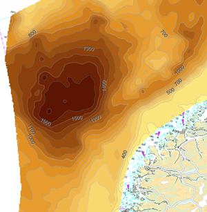
Thickness of Quaternary sediments on the Norwegian continental shelf
The data set shows the total thickness of sediments deposited on the continental shelf and slope off the south and west of Norway in the Quaternary (the last 2.6 million years). The thickness varies greatly over the mapped area, from 0 to 1800 ms twt (milliseconds two-way travel time) (about 0 to 1500 m).
Simple
- Date (Creation)
- 2018-04-26
- Date (Publication)
- 2018-11-26
- Date (Revision)
- 2018-04-26
- Unique resource identifier
- sedimentmektighet_kvartaer
- Purpose
-
The map shows the thickness of sediments deposited on the Norwegian continental shelf during the last 2.6 million years. The data forms the basis for further research and investigations and support for development on the seabed.
- Status
- Completed
- Maintenance and update frequency
- Not planned
- GEMET - INSPIRE themes, version 1.0
-
-
Geologi
-
Havområder
-
- Nasjonal inndeling i geografiske initiativ og SDI-er
-
-
Norway Digital
-
Felles datakatalog
-
- Nasjonal tematisk inndeling (DOK-kategori)
-
-
Geologi
-
Landskap
-
Vær og klima
-
- Place
-
-
Nordsjøen
-
Norskehavet
-
Skagerrak
-
- Theme
-
-
sediment
-
seabed
-
thickness
-
Quaternary
-
continental shelf
-
ise age
-
geological history
-
glacier
-
- Specific usage
-
During many ice ages in the Quaternary, the land areas in Scandinavia and the North Sea and the continental shelf west of Norway were covered by ice. The map shows where most of the sediments have been deposited on the shelf. There are two large depositional areas outside central Norway with sediment thicknesses of up to 1,500 m, while in the Skagerrak and the coastal areas there is only a thin sediment cover or bare rock. This knowledge is important for understanding the geological history of the area. The composition and thickness of the sediments on the seabed set the conditions for both life in the sea and human activities such as fishing, development, nature conservation, seabed installations, etc.
- Use limitation
-
Detaljnivået på datasettet tilsier bruk innenfor kartmålestokken: 1:500.000 - 1:5 000.000.
- Access constraints
- Other restrictions
- Other constraints
- Åpne data
- Use constraints
- Other restrictions
- Other constraints
- No conditions apply to access and use
- Classification
- Unclassified
- Spatial representation type
- Grid
- Denominator
- 500 000
- Metadata language
- Norwegian
- Topic category
-
- Geoscientific information
))
- Begin date
- 0001-01-01
- Supplemental Information
-
The thickness is given in milliseconds two-way travel time (ms twt). 1 ms twt corresponds to approx. 1 m at a sound velocity of 2000 m/s in the sediments.
- Unique resource identifier
- EPSG:32633
- Distribution format
-
-
TIFF
()
Distributor
- Units of distribution
-
Region
- Protocol
-
WWW:DOWNLOAD-1.0-http--download
-
TIFF
()
- Units of distribution
-
Region
- Protocol
-
WWW:DOWNLOAD-1.0-http--download
- Hierarchy level
- Dataset
Completeness omission
- Name of measure
- Grad av FAIR dataleveranse
- Measure description
-
Angir fullstendighet i forhold til krav fra FAIR-prinsippene (The FAIR Guiding Principles for scientific data management and stewardship)
Quantitative result
- Value
- 66
- File identifier
- 6e5c33bc-b0f9-48c7-8c8b-221d9f2b82c7 XML
- Metadata language
- Norwegian
- Hierarchy level
- Dataset
- Date stamp
- 2024-09-04
- Metadata standard name
-
ISO19115
- Metadata standard version
-
2003
Overviews


Spatial extent
Provided by
