 geonetworktest
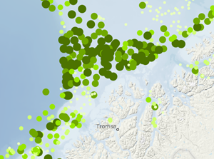
Artsmangfold – Videoobservasjoner
Datasettet viser antall observerte ulike arter pr. video-transekt og er basert på observasjoner av videomateriale av overflaten av havbunnen, samlet inn ved hjelp av videorigg. Opptak av havbunnens overflate ble gjort langs 200 m og 700 m lange transekt. Hvert punktsymbol er plottet på koordinatene for transektets midtpunkt, hvor symbolets størrelse korresponderer med antall observasjoner. MAREANO samler inn observasjoner fra videorigg for å kartlegge blant annet bunnfauna.
Simple
- Date (Creation)
- 2021-05-27
- Date (Publication)
- 2021-05-27
- Date (Revision)
- 2022-08-19
- Unique resource identifier
- artsmangfold_video_observasjoner
- Purpose
-
Datasettet viser artsmangfoldet ved havbunnen. Det bør tas hensyn til dette artsmangfoldet i forbindelsen med planlegging av aktiviteter som kan føre til forstyrrelser av artsmangfoldet. Datasettet kan brukes som et verktøy for marin areal- og miljøplanlegging, sårbarhetsanalyser, habitatskartlegging og i forbindelse med installasjoner på havbunnen og aktiviteter som kan ha påvirkning på havbunnen. Videre kan datasettet brukes som beslutningsgrunnlag ved vurdering av nye oppdrettskonsesjoner, utslipp i sjø, deponering, utbygging av petroleumsrelaterte installasjoner, og regulering av fiskeriaktivitet.
- Status
- Completed
- Maintenance and update frequency
- Annually
- Nasjonal inndeling i geografiske initiativ og SDI-er
-
-
Mareano
-
Norway Digital
-
- Nasjonal tematisk inndeling (DOK-kategori)
-
-
Kyst og fiskeri
-
Natur
-
- Place
-
-
Norske havområder nord for 62. breddegrad
-
- Theme
-
-
videotransekt
-
arter
-
observasjon
-
- Use limitation
-
Ingen begrensninger på bruk er oppgitt.
- Access constraints
- Other restrictions
- Other constraints
- Åpne data
- Use constraints
- Other restrictions
- Other constraints
- Norsk lisens for offentlige data (NLOD)
- Classification
- Unclassified
- Spatial representation type
- Vector
- Denominator
- 500000
- Metadata language
- Norwegian
- Topic category
-
- Biota
))
- Begin date
- 0001-01-01
- Unique resource identifier
- EPSG:25833
- Unique resource identifier
- EPSG:3035
- Unique resource identifier
- EPSG:4258
- Distribution format
-
-
FGDB
(
10.0
)
Distributor
- Units of distribution
-
landsfiler
- OnLine resource
- https://nedlasting.test.geonorge.no/api/capabilities/ ( GEONORGE:DOWNLOAD )
-
GML
()
Distributor
- Units of distribution
-
landsfiler
- OnLine resource
- https://nedlasting.test.geonorge.no/api/capabilities/ ( GEONORGE:DOWNLOAD )
-
GML
(
3.2.1
)
Distributor
- Units of distribution
-
landsfiler
- OnLine resource
- https://nedlasting.test.geonorge.no/api/capabilities/ ( GEONORGE:DOWNLOAD )
-
PostGIS
()
Distributor
- Units of distribution
-
landsfiler
- OnLine resource
- https://nedlasting.test.geonorge.no/api/capabilities/ ( GEONORGE:DOWNLOAD )
-
PostGIS
(
12
)
Distributor
- Units of distribution
-
landsfiler
- OnLine resource
- https://nedlasting.test.geonorge.no/api/capabilities/ ( GEONORGE:DOWNLOAD )
-
SOSI
(
4.5
)
Distributor
- Units of distribution
-
landsfiler
- OnLine resource
- https://nedlasting.test.geonorge.no/api/capabilities/ ( GEONORGE:DOWNLOAD )
-
FGDB
()
Distributor
- OnLine resource
- http://nedlasting2.geonorge.no/geonorge/ATOM-feeds/ArtsmangfoldVideoObs_AtomFeedFGDB.xml ( W3C:AtomFeed )
-
GML
()
Distributor
- OnLine resource
- http://nedlasting2.geonorge.no/geonorge/ATOM-feeds/ArtsmangfoldVideoObs_AtomFeedGML.xml ( W3C:AtomFeed )
-
PostGIS
()
Distributor
- OnLine resource
- http://nedlasting2.geonorge.no/geonorge/ATOM-feeds/ArtsmangfoldVideoObs_AtomFeedPOSTGIS.xml ( W3C:AtomFeed )
-
SOSI
()
Distributor
- OnLine resource
- http://nedlasting2.geonorge.no/geonorge/ATOM-feeds/ArtsmangfoldVideoObs_AtomFeedSOSI.xml ( W3C:AtomFeed )
-
FGDB
(
10.0
)
- Units of distribution
-
landsfiler
- OnLine resource
- https://nedlasting.test.geonorge.no/api/capabilities/ ( GEONORGE:DOWNLOAD )
- Hierarchy level
- Dataset
Domain consistency
Conformance result
- Date (Publication)
- Date
- Explanation
-
The data is according to the product specification
- Pass
- Yes
Conformance result
- Date (Publication)
- Date
- Explanation
-
SOSI files are according to application form
- Pass
- Yes
Domain consistency
Conformance result
- Date (Publication)
- Date
- Explanation
-
GML files are according to application form
- Pass
- Yes
Conformance result
- Date
- Date
- Explanation
-
Datasettets faktiske kartlagte areal i forhold til datasettets spesifiserte utstrekning
Conformance result
- Date
- Date
- Explanation
-
Angir fullstendighet i forhold til krav fra FAIR-prinsippene (The FAIR Guiding Principles for scientific data management and stewardship)
- File identifier
- ffb4ad9b-64d4-4387-a01a-1a8137f9dc84 XML
- Metadata language
- Norwegian
- Hierarchy level
- Dataset
- Date stamp
- 2025-04-27
- Metadata standard name
-
ISO19115
- Metadata standard version
-
2003
Overviews


Spatial extent
Provided by
