 geonetworktest
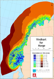
Wind resources
Kjeller Vindteknikk has on assignment from NVE made a national feasibility study of the available wind resources, both onshore and offshore.
The map product has a horisontal resolution of 1x1km, and gives annual avarage at 50, 80 and 120m above the ground. The maps are available as downloadable PDF-files.
In addition to available wind resources, maps of terrain complexity and risk for icing has been developed. Terrain complexity maps are an indicator on the vulnerability of turbolent air flows in an area.
Turbolent air flows can be a challenge for wind turbines and will normally contribute to reduced power production and increased wearing on the wind turbines.
Icing on turbine blades can be a problem in exposed areas, especially at higher altitudes, and contributes to reduction in power efficiency and power production.
Simple
- Date (Creation)
- 2017-11-08
- Date (Publication)
- 2017-11-08
- Date (Revision)
- 2017-11-08
- Unique resource identifier
- vindressurser
- Purpose
-
Kjeller Vindteknikk has on assignment from NVE made a national feasibility study of the available wind resources, both onshore and offshore.
The map product has a horisontal resolution of 1x1km, and gives annual avarage at 50, 80 and 120m above the ground. The maps are available as downloadable PDF-files.
- Maintenance and update frequency
- Unknown
- GEMET - INSPIRE themes, version 1.0
-
-
Energy resources
-
- Nasjonal inndeling i geografiske initiativ og SDI-er
-
-
Norway Digital
-
National public data catalog
-
- Keywords
-
-
Vindressurser
-
Vindstyrke
-
Brukstimer
-
Isingspotensial
-
Terrengkompleksitet
-
Vind
-
- Access constraints
- Other restrictions
- Other constraints
- Åpne data
- Use constraints
- Other restrictions
- Other constraints
- Norsk lisens for offentlige data (NLOD)
- Spatial representation type
- Vector
- Denominator
- 50
- Metadata language
- Norwegian
))
- Begin date
- 0001-01-01
- Distribution format
-
-
ESRI Shape
()
Distributor
- Units of distribution
-
Country
- OnLine resource
- http://nedlasting.nve.no/gis/ ( WWW:DOWNLOAD-1.0-http--download )
-
ESRI Filgeodatabase
()
Distributor
- Units of distribution
-
Country
- OnLine resource
- http://nedlasting.nve.no/gis/ ( WWW:DOWNLOAD-1.0-http--download )
-
GeoJSON
(
1.0
)
Distributor
- Units of distribution
-
Country
- OnLine resource
- http://nedlasting.nve.no/gis/ ( WWW:DOWNLOAD-1.0-http--download )
-
gml
()
Distributor
- Units of distribution
-
Country
- OnLine resource
- http://nedlasting.nve.no/gis/ ( WWW:DOWNLOAD-1.0-http--download )
-
SOSI
()
Distributor
- Units of distribution
-
Country
- OnLine resource
- http://nedlasting.nve.no/gis/ ( WWW:DOWNLOAD-1.0-http--download )
-
KML
()
Distributor
- Units of distribution
-
Country
- OnLine resource
- http://nedlasting.nve.no/gis/ ( WWW:DOWNLOAD-1.0-http--download )
-
ESRI Shape
()
- Units of distribution
-
Country
- OnLine resource
- http://nedlasting.nve.no/gis/ ( WWW:DOWNLOAD-1.0-http--download )
- Hierarchy level
- Dataset
- File identifier
- 21079f3d-81b8-405b-bfb1-c213d732fcfb XML
- Metadata language
- Norwegian
- Hierarchy level
- Dataset
- Date stamp
- 2021-06-01
- Metadata standard name
-
ISO19115
- Metadata standard version
-
2003
Overviews


Spatial extent
Provided by
