 geonetworktest
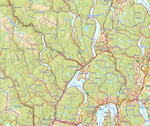
N5000 Kartdata - historiske data 2015
N5000 Kartdata er tilpasset målestokk 1:3 000 000 til
1:7 000 000 og dekker fastlands-Norge begrenset av riksgrensen mot nabolandene og territorialgrensen i havet. Kartdatabasen er en generalisering av N2000 Kartdata og er kartografisk redigert med tanke på presentasjon i målestokk 1: 5 000 000.
Simple
- Date (Creation)
- 2020-04-20
- Date (Publication)
- 2020-04-20
- Date (Revision)
- 2015-03-04
- Unique resource identifier
- n5000_2015
- Status
- Completed
- Maintenance and update frequency
- Not planned
- Nasjonal inndeling i geografiske initiativ og SDI-er
-
-
Norway Digital
-
fellesDatakatalog
-
- Specific usage
-
Dataene egner seg blant annet for fremstilling av interaktive kart, topografiske kart, temakart, som
datagrunnlag for kartløsninger på internett og i analysesammenheng.
- Use limitation
-
Ingen begrensninger på bruk er oppgitt.
- Access constraints
- Other restrictions
- Other constraints
- Åpne data
- Use constraints
- Other restrictions
- Other constraints
- Creative Commons BY 4.0 (CC BY 4.0)
- Classification
- Unclassified
- Spatial representation type
- Vector
- Denominator
- 5000000
- Metadata language
- Norwegian
- Topic category
-
- Imagery base maps earth cover
))
- Begin date
- 0001-01-01
- Supplemental Information
-
Trenger du hjelp til å laste ned og ta i bruk Kartverkets data og tjenester? På kartverket.no finner du tips og veiledning
- Unique resource identifier
- EPSG:25833
- Distribution format
-
-
FGDB
(
10.0
)
Distributor
- Units of distribution
-
landsfiler
- OnLine resource
- https://nedlasting.test.geonorge.no/api/capabilities/ ( GEONORGE:DOWNLOAD )
-
PostGIS
(
9.4
)
Distributor
- Units of distribution
-
landsfiler
- OnLine resource
- https://nedlasting.test.geonorge.no/api/capabilities/ ( GEONORGE:DOWNLOAD )
-
SOSI
()
Distributor
- Units of distribution
-
landsfiler
- OnLine resource
- https://nedlasting.test.geonorge.no/api/capabilities/ ( GEONORGE:DOWNLOAD )
-
FGDB
()
Distributor
- OnLine resource
- http://nedlasting2.geonorge.no/geonorge/ATOM-feeds/N5000KartdataHistoriskeData2015_AtomFeedFGDB.xml ( W3C:AtomFeed )
-
PostGIS
()
Distributor
- OnLine resource
- http://nedlasting2.geonorge.no/geonorge/ATOM-feeds/N5000KartdataHistoriskeData2015_AtomFeedPostGIS.xml ( W3C:AtomFeed )
-
SOSI
()
Distributor
- OnLine resource
- http://nedlasting2.geonorge.no/geonorge/ATOM-feeds/N5000KartdataHistoriskeData2015_AtomFeedSOSI.xml ( W3C:AtomFeed )
-
FGDB
(
10.0
)
- Units of distribution
-
landsfiler
- OnLine resource
- https://nedlasting.test.geonorge.no/api/capabilities/ ( GEONORGE:DOWNLOAD )
- Hierarchy level
- Dataset
- File identifier
- 65fa1200-2cbf-4a65-8ceb-9a9f1627f119 XML
- Metadata language
- Norwegian
- Parent identifier
-
N5000 Map data - historical versions
cbbff544-064e-4280-95be-0875159362ee
- Hierarchy level
- Dataset
- Date stamp
- 2025-04-23
- Metadata standard name
-
ISO19115
- Metadata standard version
-
2003
Overviews


Spatial extent
Provided by
