 geonetworktest
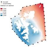
Middelvann over sjøkartnull - Svalbard
Dette er ein modell som estimerer høgdeforskjellen frå sjøkartnull opp til middelvatn. Modellen er laga ved hjelp av kollokasjon, basert på data frå ein numerisk havmodell langs randen, og nokre for det meste relativt korte måleseriar av vasstand langs kysten.
Simple
- Date (Creation)
- 2022-10-05
- Date (Publication)
- 2022-10-05
- Date (Revision)
- 2022-10-05
- Maintenance and update frequency
- Unknown
- Keywords
-
-
separasjonsmodell
-
- Access constraints
- Other restrictions
- Other constraints
- Åpne data
- Use constraints
- Other restrictions
- Other constraints
- Creative Commons BY 4.0 (CC BY 4.0)
- Spatial representation type
- Grid
- Metadata language
- Norwegian
N
S
E
W
))
- Begin date
- 0001-01-01
- Unique resource identifier
- EPSG:9999
- Distribution format
-
-
BIN
()
Distributor
- Units of distribution
-
landsfiler
- OnLine resource
- https://nedlasting.test.geonorge.no/api/capabilities/ ( GEONORGE:DOWNLOAD )
-
GeoTIFF
()
Distributor
- Units of distribution
-
landsfiler
- OnLine resource
- https://nedlasting.test.geonorge.no/api/capabilities/ ( GEONORGE:DOWNLOAD )
-
BIN
()
Distributor
- OnLine resource
- http://nedlasting2.geonorge.no/geonorge/ATOM-feeds/MiddelvannOverSjokartnullSvalbard_AtomFeedBIN.xml ( W3C:AtomFeed )
-
GeoTIFF
()
Distributor
- OnLine resource
- http://nedlasting2.geonorge.no/geonorge/ATOM-feeds/MiddelvannOverSjokartnullSvalbard_AtomFeedGeoTIFF.xml ( W3C:AtomFeed )
-
BIN
()
- Units of distribution
-
landsfiler
- OnLine resource
- https://nedlasting.test.geonorge.no/api/capabilities/ ( GEONORGE:DOWNLOAD )
- Hierarchy level
- Dataset
- File identifier
- b4f652c8-9478-4f65-8a22-c750cfd42ab3 XML
- Metadata language
- Norwegian
- Hierarchy level
- Dataset
- Date stamp
- 2025-04-23
- Metadata standard name
-
ISO19115
- Metadata standard version
-
2003
Overviews

original
miniatyrbilde

medium
Spatial extent
N
S
E
W
Provided by

Associated resources
Not available