 geonetworktest
50
Type of resources
Available actions
Topics
Keywords
Contact for the resource
Provided by
Years
Formats
Representation types
Update frequencies
Scale
-
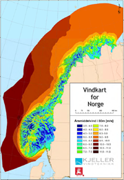
Kjeller Vindteknikk has on assignment from NVE made a national feasibility study of the available wind resources, both onshore and offshore. The map product has a horisontal resolution of 1x1km, and gives annual avarage at 50, 80 and 120m above the ground. The maps are available as downloadable PDF-files. In addition to available wind resources, maps of terrain complexity and risk for icing has been developed. Terrain complexity maps are an indicator on the vulnerability of turbolent air flows in an area. Turbolent air flows can be a challenge for wind turbines and will normally contribute to reduced power production and increased wearing on the wind turbines. Icing on turbine blades can be a problem in exposed areas, especially at higher altitudes, and contributes to reduction in power efficiency and power production.
-

The Norwegian Water Resources and Energy Directorate's susceptibility map for flooding is a national map at a general level which shows which areas may be vulnerable to flooding. It will never be possible to make the map entirely accurate, but it is good enough to provide an indication of where the risk of flooding should be assessed in greater detail if new development is in the offing. The information on the map can be used as an initial assessment base in impact assessment and/or risk and vulnerability analyses linked with the municipal plan, and in order to identify potential flood hazard areas. The potential hazard areas can be used as a basis when establishing flood zones requiring special consideration and planning provisions.
-

NEVINA (Nedbørfelt- og vannføringsindeksanalyse) er en karttjeneste der du kan beregne nedbørfelt, feltparametere, flom- og lavvannsindekser for et fritt valgt punkt i vassdraget.