 geonetworktest
Svalbard
Type of resources
Available actions
Topics
Keywords
Contact for the resource
Provided by
Years
Formats
Representation types
Update frequencies
status
Service types
Scale
-
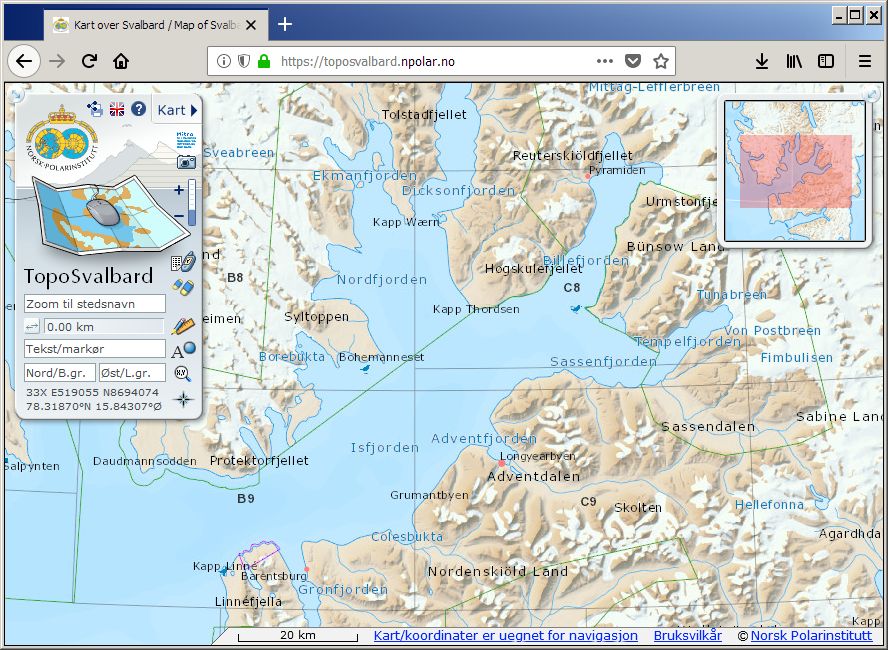
TopoSvalbard is the Norwegian Polar Institute's topographical application for Svalbard, and contains map, orthophoto and satellite image layers (summer and winter), nautical charts (Norwegian Mapping Authority), as well as terrain visualisations in 2D and 3D. Beyond basic functionality as coordinate readings and place name searches, distance measurements and data plotting, the user can also browse place names information, landscape photos, old oblique aerial photos and singular currently unrectified aerial images.
-
Bearded seal biotelemetry data
-

Se beskrivelse av datasettet.
-

Se beskrivelse av datasettet.
-
Bottom mounted ADCP plus temperature chain at entrance to Brepollen, Hornsund, Svalbard
-
The data set covers the marine biological transect from Kongsfjorden to Fram Strait (KongHau transect) within the framework of the Environmental monitoring of Svalbard and Jan Mayen (http://www.mosj.no/en/) program. The data set covers summers 2009-2014 for nutrients and chlorophyll a (Chl a) and summer 2009-2013 for protist (including phytoplankton and protozooplankton) abundance. The results published in Hegseth et al. 2019 (see the "Citation Custom" field) are based on this data set. Norwegian Polar Institute"s marine database will contain extended data from the KongHau transect, and any users post-2019 are encouraged to use the extended data set instead.
-
-
NO<br> Datasettet viser strandtyper over hele Svalbard. Tre ulike attributter er lagt inn på en kystlinje fra kart i 1:250.000: Kystgeomorfologi (landform) (FORM), kornstørrelse for strandmaterialet (MATR) og spesielle strandformer (SPES). Klassifiseringen er i hovedsak gjort ved hjelp av flyfotostudier. Metodikk og datagrunnlag er beskrevet i den medfølgende kartbeskrivelsen (pdf). For hoveddelen av området er klassifiseringsgrunnlaget bilder fra 1969-1971. Ellers er det brukt bilder fra andre tidspunkter, der de eldste stammer fra 1936 og de nyeste fra 1990. Kystlinjen er oppdatert i 2009. <br><br> EN<br> The dataset shows the coastal geomorphology of Svalbard. The geomorphology is classified by three different attributes on a 1:250000 scale coastline: Coastal geomorphology (landform) (FORM), grain size of the beach material (MATR) and special features (SPES). The classification is mainly based on aerial photography. Methodology and data are described in the accompanying map description (pdf, in Norwegian). For most of the area, the classification is based on aerial images from 1969-1971. Older or newer images have been used for the remaining areas; the oldest from as far back as 1936 and the newest from 1990. The coastline was updated in 2009.
-

Webmap solution dedicated for the Norwegian Coastal Administration's preperadness organisation.
-

Datasettet stedfester de ulike reglene for motorferdsel på Svalbard. På Svalbard er det ulike regler for tilreisende og fastboende, der fastboende har flere rettigheter til motorferdsel enn tilreisende. Karttjenesten har kartlag for hver av de to brukergruppene. Reglene for motorferdsel er hjemlet i forskrift om motorferdsel på Svalbard.